1
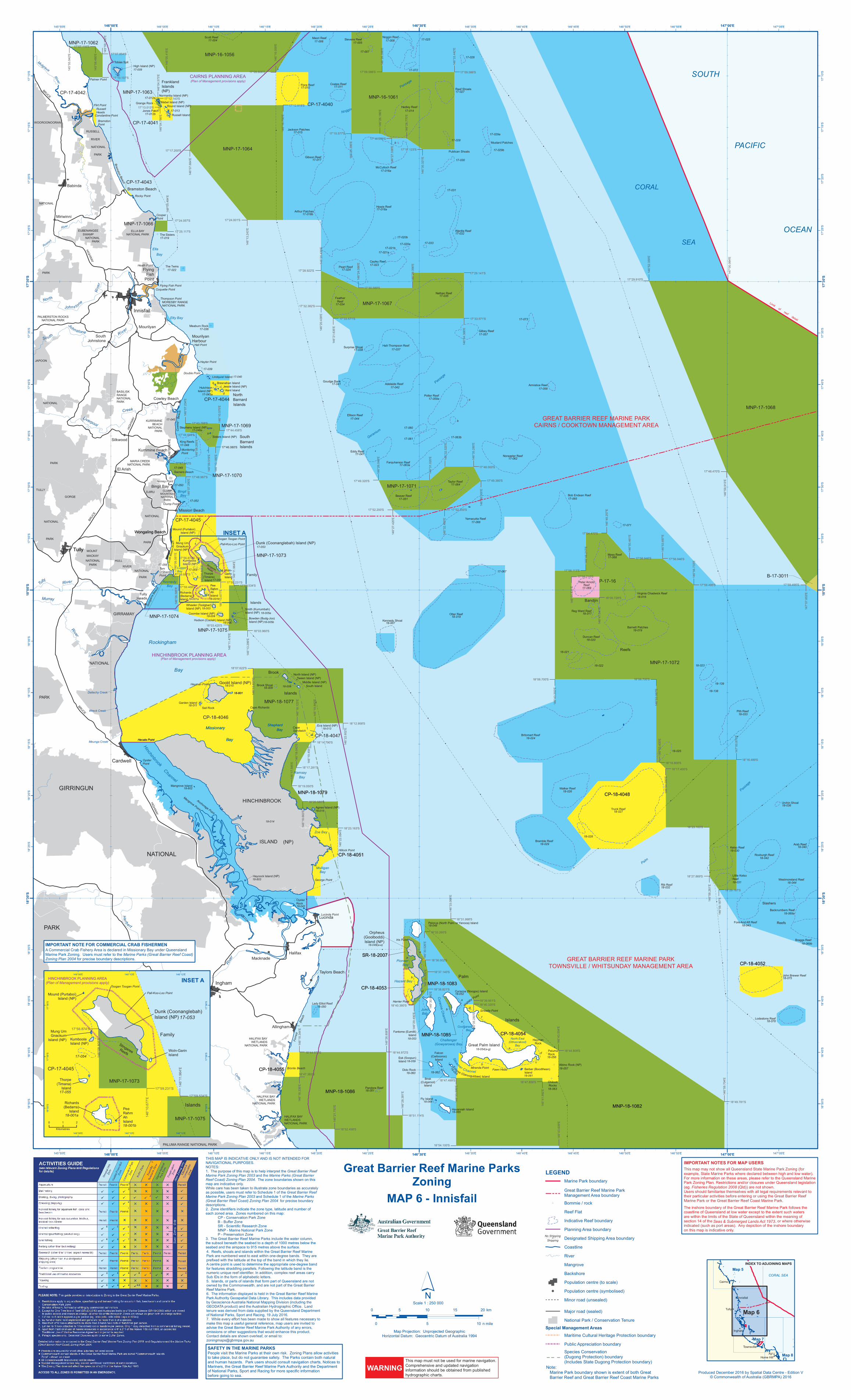
L L L L L L L L L L L L L L L # # # # # # # # # # # # # # # # # # # # # # # # # # # # # # # # # # # # # # # # # # # # # # # # # # # # # # # # # # # # # # # # # # # # # # # # # # # # # # # # # # # # # # # # # # # # # # # # # # # # # # # # # # # # # # # # # # # ! ! ! ! ! ! ! ! ! ! ! ! ! ! ! ! ! MNP-16-1056 MNP-17-1064 CP-17-4040 MNP-16-1061 MNP-17-1067 MNP-17-1072 CP-17-4043 CP-17-4042 MNP-17-1066 B-17-3011 MNP-17-1062 MNP-17-1063 CP-17-4041 MNP-17-1070 MNP-18-1079 MNP-18-1077 MNP-17-1069 CP-17-4044 MNP-17-1075 MNP-17-1068 P-17-16 CP-18-4046 CP-18-4051 MNP-18-1083 CP-18-4054 CP-18-4055 MNP-18-1082 CP-18-4052 CP-18-4053 SR-18-2007 MNP-18-1085 CP-18-4047 MNP-17-1071 MNP-18-1086 CP-17-4045 CP-18-4048 MNP-17-1074 MNP-17-1073 (Plan of Management provisions apply) CAIRNS PLANNING AREA HINCHINBROOK PLANNING AREA (Plan of Management provisions apply) MNP-18-1079 CP-18-4051 MNP-18-1083 CP-18-4054 CP-18-4055 MNP-18-1082 CP-18-4052 CP-18-4053 SR-18-2007 MNP-18-1085 MNP-18-1086 CP-18-4048 Palmer Point Cowley Beach Liver poo l Cr e e k Russell Heads Br a m s ton B e a ch Rocky Point Coquette Point MORESBY RANGE NATIONAL PARK Mourilyan Harbour G o o g a r r a B e ach Toogan Toogan Point Miriwinni DJIRU NATIONAL PARK MOUNT MACKAY NATIONAL PARK Bronte Beach C a tt l e Cre e k El e a no r C reek Garners Beach Bramston Point Innisfail JAPOON NATIONAL PARK BASILISK RANGE NATIONAL PARK Tully CLUMP MOUNTAIN NATIONAL PARK Lucinda Point Wa l l a by P o int Insulato r C r eek Iris Point Meunga Creek GIRRAMAY NATIONAL PARK Mangrove Point Anchorage Point Sinballa Point Fawn Head F o r r e st Be ac h Miranda Point Allingham Halifax Trebonne Lucinda BRU C E H I GHW A Y Tully Hecate Point Double Point Hall Point Flying Fish Point Flirt Point Mu lg ra v e R i v e r RUSSELL RIVER NATIONAL PARK Babinda ELLA BAY NATIONAL PARK EUBENANGEE SWAMP NATIONAL PARK R u s s e ll R i ver BRUCE H I GH W AY PALMERSTON ROCKS NATIONAL PARK S o u t h Jo h n s t on e R i v e r M ur ray R i ve r Bramston Beach WOOROONOORAN NATIONAL PARK Hecate Point Thompson Point Hayter Point Hayman Point Mourilyan Wongaling Beach South Johnstone N o r t h J o h n s t o n e R i v e r Constantine Point Cooper Point El Arish Kurrimine Beach Oyster Point Cardwell HULL RIVER NATIONAL PARK Dallachy Creek Heath Point Flying Fish Point Wreck Creek George Point Cape Richards Clump Point KURRIMINE BEACH NATIONAL PARK MARIA CREEK NATIONAL PARK BRU CE H IG H WAY HALIFAX BAY WETLANDS NATIONAL PARK HALIFAX BAY WETLANDS NATIONAL PARK Ingham H e r b e r t R iv er St o ne R i v e r B R UCE HIGHW AY PALUMA RANGE NATIONAL PARK Silkwood TULLY GORGE NATIONAL PARK Tul ly R iv e r GIRRINGUN NATIONAL PARK Murdering Point Hillock Point Harrier Point Ninney Point C o w l e y B e a c h Palm Creek Tam O'Shanter Point Cape Sandwich Tully Heads Bingil Bay Wongaling Beach Taylors Beach Macknade Mission Beach S o ut h M is s i on B e a c h Pall-Koo-Loo Point HALIFAX BAY WETLANDS NATIONAL PARK Orient C ree k Virginia Chadwick Reef Scott Reef 17-004 17-020a Stevens Reef 17-073 Normanby Island (NP) Mabel Island (NP) Garden Island High Island (NP) Great Palm Island E c li p s e ( Gar o og ubb ee) Island Wheeler (Toolgbar) Island (NP) Brisk (Culgarool) Island South Island North Island (NP) Tween Island (NP) Middle Island (NP) Falcon (Carbooroo) Island Lindquist Island Dunk (Coonanglebah) Island (NP) Round Island (NP) Jessie Island (NP) Fly Island Mound (Purtaboi) Island (NP) Bowden (Budg-Joo) Island (NP) Sisters Island (NP) Pelorus (North Palm or Yanooa) Island Esk (Soopun) Island Goold Island (NP) Russell Island Bresnahan Island HINCHINBROOK ISLAND (NP) Curacoa (Noogoo) Island Woln- Garin Island Stephens Island (NP) Hutchison Island (NP) Hudson (Coolah) Island (NP) Coombe Island (NP) 18-021 17-071 18-138 Kumboola Island (NP) Thorpe (Timana) Island Richards (Bedarra) Island Kent Island Pee Rahm Ah Island Smith (Kurrumbah) Island (NP) Eva Island (NP) Mung Um Gnackum Island (NP) Barber (Boodthean) Island Mangrove Island Agnes Island (NP) Haycock Island (NP) Havannah Island Orpheus (Goolboddi) Island (NP) Fantome (Eumilli) Island Limit of reef detail GREAT BARRIER REEF MARINE PARK TOWNSVILLE / WHITSUNDAY MANAGEMENT AREA GREAT BARRIER REEF MARINE PARK CAIRNS / COOKTOWN MANAGEMENT AREA The Sisters Meaburn Rock Oyster Rock The Twins Chilcott Rocks Grange Rock Dido Rock Albino Rock (NP) Hayman Rock Sail Rock Paluma Rock South Barnard Islands Bandjin Reefs Family Islands North Barnard Islands Brook Islands Slashers Reefs Palm Islands Frankland Islands (NP) Raaf Shoals Pith Reef Bramble Reef Braggs Reef Jones Patch Jackson Patches John Brewer Reef Farquharson Reef Surprise Shoal Goudge Bank Trunk Reef Ellison Reef Beaver Reef Nathan Reef Hall-Thompson Reef Hedley Reef Gibson Reef Flora Reef Adelaide Reef Gilbey Reef Backnumbers Reef Coates Reef Peart Reef Kennedy Shoal Noreaster Reef Armistice Reef Yamacutta Reef Cayley Reef Reg Ward Reef Feather Reef McCulloch Reef Pandora Reef Fore And Aft Reef Urchin Shoal Barnett Patches Duncan Reef Little Kelso Reef Noggin Reef Tobias Spit Otter Reef Mustard Patches Publican Shoals Potter Reef Maori Reef Lodestone Reef Arthur Patches Wardle Reef Howie Reef Walker Reef Rib Reef Roxburgh Reef Kelso Reef Arab Reef Westmoreland Reef Eddy Reef Stingaree Reefs Lady Elliot Reef Brook Shoal Moss Reef Britomart Reef King Reefs Taylor Reef 17-012a 17-029a 17-029b 17-028 17-030 17-019 17-027 18-020 18-023 18-033 18-069b 17-012b a 18-801 17-040 17-041 18-801 17-038 18-139 18-025 18-041 17-009 18-005a 18-027 17-035 17-037 17-054 17-022 17-056 b 18-063 17-063a 18-062 18-013 18-059 18-075 17-014 17-015 17-017 17-010 17-042 17-057 17-026 18-069a 18-056 17-011 17-021b 17-021a 18-022 18 -0 5 8 c 17-050 18-054(a-g) 18-049(a-e) 17-059a b 17-020b a b e b c d e f 17-062 17-058 17-051 17-023 17-043a 18-014 a 18-044 17-007 18-017 17-034 18-048 17-024 17-033 17-016a 18-003 18-008 18-060 18-051 18-064 18-043 18-019 18-031 17-008 17-025 b c d 17-013 17-005 17-066 18-010 17-049 17-044 18-036 18-024 18-018 18-007 17-031 b c 17-063b 17-067 18-052 17-006 17-039 b 18-026 17-046a 18-005b 18-078 17-036 17-018b 17-032 17-018a 18-029 18-032 18-042 18-030 18-040 18-006 18-004 17-047 17-060 17-061 17-055 18-001b 17-069 18-028 17-053 18-057 17-052 17-065 18-016 18-803 18-050 18-061 18-065 18-011 18-009 18-802 17-068 18-015 17-045 17-048 18-001a 17-064 g 18-053 d 17-072 Mulligan Bay Zoe Bay Coolgaree Bay Challenger (Gowyarowa) Bay G eranium P assage Shepherd Bay Bingil Bay Pioneer Bay Missionary Bay SOUTH PACIFIC OCEAN N og gin Pa s sage Etty Bay Rockingham Bay Missionary Bay Shepherd Bay Lugger Bay C u r a c o a C h a nne l S te a m e r C h a nn e l H inc h i n b r o ok C h ann e l Pal m P as sage CORAL SEA Kennedy Bay Hazard Bay North East (Dthoorakool) Bay Ella Bay Ramsay Bay Juno Bay Peter Arnold Reef Bob Endean Reef 146°05.415'E 146°43.609'E 18°16.800'S 17°09.586'S 146°33.442'E 146°26.398'E 17°09.586'S 17°07.116'S 145°58.480'E 18°31.998'S 146°30.526'E 146°35.280'E 18°40.320'S 18°47.856'S 146°41.992'E 146°10.677'E 145°59.180'E 17°07.854'S 146°04.573'E 17°12.143'S 17°13.013'S 146°04.786'E 146°16.059'E 17°09.606'S 17°12.818'S 146°16.750'E 146°23.395'E 17°15.577'S 17°16.059'S 146°27.338'E 146°30.321'E 17°17.123'S 17°28.922'S 146°20.439'E 146°21.635'E 146°20.439'E 17°32.382'S 17°33.571'S 17°33.571'S 146°34.368'E 146°13.243'E 17°24.001'S 17°17.200'S 146°07.664'E 17°24.057'S 17°25.117'S 146°05.484'E 146°07.234'E 17°46.080'S 146°07.290'E 146°05.674'E 18°23.163'S 18°29.187'S 146°59.187'E 18°27.869'S 146°58.261'E 146°33.066'E 17°52.200'S 146°27.420'E 17°56.874'S 146°52.359'E 17°29.910'S 17°48.470'S 146°59.913'E 146°47.541'E 146°53.400'E 147°00.064'E 146°24.086'E 17°29.141'S 17°30.589'S 146°29.356'E 146°28.770'E 146°26.186'E 145°55.942'E 17°43.788'S 17°44.646'S 146°09.519'E 146°10.185'E 17°46.080'S 17°48.987'S 17°47.642'S 146°05.674'E 146°32.520'E 17°48.000'S 146°35.280'E 17°49.380'S 146°36.000'E 146°32.460'E 17°52.200'S 146°31.020'E 146°26.040'E 17°49.320'S 146°08.805'E 146°06.081'E 17°58.687'S 17°59.231'S 146°11.964'E 17°59.534'S 18°03.425'S 146°11.475'E 18°03.960'S 146°13.299'E 18°07.622'S 146°13.837'E 146°18.123'E 146°19.860'E 18°19.050'S 146°17.585'E 17°54.470'S 146°48.257'E 17°58.113'S 146°46.217'E 17°56.946'S 146°50.461'E 17°56.946'S 146°53.697'E 18°08.700'S 146°43.202'E 18°08.700'S 146°53.067'E 18°16.489'S 147°00.870'E 146°18.663'E 18°20.580'S 146°59.704'E 18°49.781'S 18°54.100'S 18°47.499'S 146°33.599'E 146°28.381'E 18°51.114'S 18°44.972'S 146°26.808'E 146°18.344'E 18°44.972'S 146°18.336'E 146°21.753'E 18°33.260'S 18°36.002'S 18°37.140'S 146°30.840'E 146°29.490'E 146°44.831'E 17°59.468'S 146°06.585'E 146°22.602'E 18°12.958'S 17°58.710'S 18°00.728'S 17°59.495'S 146°56.733'E 18°23.103'S 146°30.600'E 18°38.821'S 18°40.380'S 18°47.383'S 18°52.458'S 146°43.554'E 18°44.809'S 147°07.653'E 17°59.495'S 146°10.575'E 17°44.458'S 18°17.281'S 146°18.042'E 146°19.455'E 18°14.790'S 18°39.951'S 146°22.084'E 146°54.000'E 18°17.400'S 17°10.107'S 146°08.265'E INSET A This map must not be used for marine navigation. Comprehensive and updated navigation information should be obtained from published hydrographic charts. WARNING Produced December 2016 by Spatial Data Centre - Edition V © Commonwealth of Australia (GBRMPA) 2016 Map Projection: Unprojected Geographic Horizontal Datum: Geocentric Datum of Australia 1994 ´ Scale 1 : 250 000 0 5 10 15 20 km 0 5 10 n mile # # MNP-17-1073 MNP-17-1075 CP-17-4045 HINCHINBROOK PLANNING AREA (Plan of Management provisions apply) Toogan Toogan Point Pall-Koo-Loo Point 17-054 17-055 18-001b 18-001a Stingaree Reefs Mound (Purtaboi) Island (NP) Dunk (Coonanglebah) Island (NP) Kumboola Island (NP) Thorpe (Timana) Island Richards (Bedarra) Island Pee Rahm Ah Island Mung Um Gnackum Island (NP) Family Islands Woln-Garin Island 17-053 17°56.874'S 146°08.805'E 146°11.964'E 17°59.231'S 146°10.677'E 17°59.534'S 0 1 2 Kilometres Note: Marine Park boundary shown is extent of both Great Barrier Reef and Great Barrier Reef Coast Marine Parks ! ! ! ! ! ! Map 5 Map 6 CORAL SEA Map 8 Cairns Innisfail Tully Ingham Townsville Ayr Home Hill Map 7 INDEX TO ADJOINING MAPS INSET A 146°30'E 146°30'E 17°30'S 17°30'S 18°30'S 18°30'S 146°55'E 146°55'E 146°50'E 146°50'E 146°45'E 146°45'E 146°40'E 146°40'E 146°35'E 146°35'E 146°25'E 146°25'E 146°20'E 146°20'E 146°15'E 146°15'E 146°10'E 146°10'E 145°55'E 145°55'E 17°10'S 17°10'S 17°15'S 17°15'S 17°20'S 17°20'S 17°25'S 17°25'S 17°35'S 17°35'S 17°40'S 17°40'S 17°45'S 17°45'S 17°50'S 17°50'S 17°55'S 17°55'S 18°10'S 18°10'S 18°15'S 18°15'S 18°20'S 18°20'S 18°25'S 18°25'S 18°35'S 18°35'S 18°40'S 18°40'S 18°45'S 18°45'S 18°50'S 18°50'S 146°00'E 147°00'E 147°05'E 18°00'S 147°00'E 147°05'E 146°00'E 146°05'E 18°00'S 18°05'S Great Barrier Reef Marine Parks Zoning MAP 6 - Innisfail 146°12'E 146°12'E 146°10'E 146°10'E 17°56'S 17°56'S 17°58'S 17°58'S 146°08'E 146°08'E 18°00'S 18°00'S 146°05'E 18°05'S THIS MAP IS INDICATIVE ONLY AND IS NOT INTENDED FOR NAVIGATIONAL PURPOSES. NOTES: 1. The purpose of this map is to help interpret the Great Barrier Reef Marine Park Zoning Plan 2003 and the Marine Parks (Great Barrier Reef Coast) Zoning Plan 2004. The zone boundaries shown on this map are indicative only. While care has been taken to illustrate zone boundaries as accurately as possible, users must refer to Schedule 1 of the Great Barrier Reef Marine Park Zoning Plan 2003 and Schedule 1 of the Marine Parks (Great Barrier Reef Coast) Zoning Plan 2004 for precise boundary descriptions. 2. Zone identifiers indicate the zone type, latitude and number of each zoned area. Zones numbered on this map: CP - Conservation Park Zone B - Buffer Zone SR - Scientific Research Zone MNP - Marine National Park Zone P - Preservation Zone 3. The Great Barrier Reef Marine Parks include the water column, the subsoil beneath the seabed to a depth of 1000 metres below the seabed and the airspace to 915 metres above the surface. 4. Reefs, shoals and islands within the Great Barrier Reef Marine Park are numbered west to east within one-degree bands. They are prefixed with the latitude at the top of the band in which they lie. A centre point is used to determine the appropriate one-degree band for features straddling parallels. Following the latitude band is the numeric unique reef identifier. In addition, complex reef areas carry Sub IDs in the form of alphabetic letters. 5. Islands, or parts of islands that form part of Queensland are not owned by the Commonwealth, and are not part of the Great Barrier Reef Marine Park. 6. The information displayed is held in the Great Barrier Reef Marine Park Authority Geospatial Data Library. This includes data provided by Geoscience Australia National Mapping Division (including the GEODATA product) and the Australian Hydrographic Office. Land tenure was derived from data supplied by the Queensland Department of National Parks, Sport and Racing, 19 July 2016. 7. While every effort has been made to show all features necessary to make this map a useful general reference, map users are invited to advise the Great Barrier Reef Marine Park Authority of any errors, omissions or other suggestions that would enhance this product. Contact details are shown overleaf, or email to: [email protected] LEGEND Marine Park boundary Great Barrier Reef Marine Park Management Area boundary L Bommie / rock Reef Flat Indicative Reef boundary Planning Area boundary Designated Shipping Area boundary Coastline River Mangrove Backshore Population centre (to scale) ! Population centre (symbolised) Minor road (unsealed) Major road (sealed) National Park / Conservation Tenure Special Management Areas Maritime Cultural Heritage Protection boundary Public Appreciation boundary Species Conservation (Dugong Protection) boundary (Includes State Dugong Protection boundary) # No Shipping Shipping The inshore boundary of the Great Barrier Reef Marine Park follows the coastline of Queensland at low water except to the extent such waters are within the limits of the State of Queensland within the meaning of section 14 of the Seas & Submerged Lands Act 1973, or where otherwise indicated (such as port areas). Any depiction of the inshore boundary on this map is indicative only. IMPORTANT NOTES FOR MAP USERS Seas & Submerged Lands Act 1973 This map may not show all Queensland State Marine Park Zoning (for example, State Marine Parks where declared between high and low water). For more information on these areas, please refer to the Queensland Marine Park Zoning Plan. Restrictions and/or closures under Queensland legislation (eg. Fisheries Regulation 2008 (Qld)) are not shown. Users should familiarise themselves with all legal requirements relevant to their particular activities before entering or using the Great Barrier Reef Marine Park or the Great Barrier Reef Coast Marine Park. SAFETY IN THE MARINE PARKS People visit the Marine Parks at their own risk. Zoning Plans allow activities to take place, but do not guarantee safety. The Parks contain both natural and human hazards. Park users should consult navigation charts, Notices to Mariners, the Great Barrier Reef Marine Park Authority and the Department of National Parks, Sport and Racing for more specific information before going to sea. IMPORTANT NOTE FOR COMMERCIAL CRAB FISHERMEN A Commercial Crab Fishery Area is declared in Missionary Bay under Queensland Marine Park Zoning. Users must refer to the Marine Parks (Great Barrier Reef Coast) Zoning Plan 2004 for precise boundary descriptions.