

1
TSX-V : ADM
Proyecto Volcán SOCIEDAD NACIONAL DE MINERIA
AGOSTO 2012

2
Cautionary Notes on
Forward Looking Information
This presentation contains forward-looking information within the meaning of applicable Canadian securities laws and regulations. Such information is
based on the current expectations and beliefs of Andina’s management and is subject to a number of risks and uncertainties that may cause the actual
results to differ materially from those described above. Forward-looking information in this presentation includes, but is not limited to, statements with
respect to the completion of the feasibility study and environmental impact assessments for the Volcan Gold Project, future mining parameters
(including assumed capital construction costs, operating costs, sustaining capital costs, processing rates, strip ratio’s, mineral grades and recovery rates,
mining costs, construction costs, mill process costs, recovery rates for leach processing, recovery rates for mill processing, and pit slopes, future gold
prices (including those used to calculate Andina’s mineral resources and reserves), expected results from metallurgical testing, future recovered ounces
of gold based on pit optimizations, strip ratios, and target parameters of the feasibility study. Often, but not always, forward-looking information can be
identified by the use of words such as “plans”, “planning”, “planned”, “expects”, “looking forward”, “does not expect”, “continues”, “scheduled”,
“estimates”, “forecasts”, “intends”, “potential”, “anticipate”, “does not anticipate”, or “belief”, or describes a “goal”, or variations of such words and
phrases or state that certain actions, events or results “may”, “could”, “would”, “might” or “will” be taken, occur or be achieved.
The forward-looking information contained in this presentation is based on a number of material factors and assumptions, including, but not limited to,
that estimates and studies are accurate, that Andina’s mining operations continue in the ordinary course and as expected, that contracted parties
provide goods and/or services on the agreed time frames, that the equipment necessary for exploration and development work is available as
scheduled, availability of water for milling and mining, that no labour shortages or delays are incurred, that plant and equipment function as specified,
Andina’s ability to obtain adequate financing when and as needed, the continued favourable market for gold at prices at or above estimated levels, that
no unusual geological or technical problems occur, that no unusual or unexpected events have a material adverse effect on Andina’s operations or
financial condition, and such other assumptions and factors as set out herein. Forward-looking information involves known and unknown risks, future
events, conditions, uncertainties and other factors which may cause the actual results, performance or achievements to be materially different from
any future results, projection, forecast, performance or achievements expressed or implied by the forward-looking information. Such factors include,
among others, the interpretation and actual results of current exploration activities; changes in project parameters as plans continue to be refined;
future prices of gold; possible variations in grade or recovery rates; failure of equipment or processes to operate as anticipated; the failure of
contracted parties to perform; labour disputes and other risks of the mining industry; delays in obtaining governmental approvals or financing or in the
completion of exploration, as well as those factors disclosed in the company's publicly filed documents. Although Andina has attempted to identify
important factors that could cause actual actions, events or results to differ materially from those described in forward-looking information, there may
be other factors that cause actions, events or results not to be as anticipated, estimated or intended. There can be no assurance that forward-looking
information will prove to be accurate, as actual results and future events could differ materially from those anticipated in such statements. Accordingly,
readers should not place undue reliance on forward-looking information. Andina does not undertake any obligation to update or revise publicly any
forward-looking information whether as a result of new information, future events or otherwise, unless required to do so by applicable laws.

3
National Instrument 43-101 Disclosure
In accordance with National Instrument 43-101 (“NI 43-101”) of the Canadian Securities Administrators, the qualified personsfor the Volcan Gold Project are Messrs. Richard Gowans, P. Eng., Sam Shoemaker, MAUSIMM, and Reno Pressacco, P. Geo.of Micon International Inc. A NI 43-101 compliant technical report for the Dorado area deposits, prepared by Micon and datedJanuary 31, 2011, is available on the SEDAR filing system at www.sedar.com.
The 2010 inferred mineral resource estimate total did not incorporate the Ojo de Agua inferred resource from the October 2008Resource Estimate for the Ojo de Agua area certified by Mr. Michael Easdon, as no material changes had occurred withrespect to this deposit. Details on the Ojo de Agua mineral resource estimate can be found in Andina’s October 6, 2008 pressrelease filed at www.sedar.com. Mr. Easdon is a professional geologist registered with the State of Oregon, USA and is theQualified Person for the Ojo de Agua inferred resource and the Ojo de Agua East indicated and inferred resource.
A ‘probable mineral reserve’ is the economically mineable part of an indicated and, in some circumstances, a measuredmineral resource demonstrated by at least a preliminary feasibility study. A ‘proven mineral reserve’ is the economicallymineable part of a measured mineral resource demonstrated by at least a preliminary feasibility study.
A ‘measured mineral resource’ and an ‘indicated mineral resource’ is that part of a mineral resource for which quantity, grade orquality, densities, shape and physical characteristics, can be estimated with a level of confidence sufficient to allow theappropriate application of technical and economic parameters, to support mine planning and evaluation of the economicviability of the deposit. The ‘measured mineral resource’ requires a higher level of confidence in, and understanding of, thegeology and controls of the mineral deposit as compared to an ‘indicated mineral resource’. An ‘inferred mineral resource’ isthat part of a mineral resource for which quantity and grade or quality can be estimated on the basis of geological evidence andlimited sampling and reasonably assumed, but not verified, geological and grade continuity.
It cannot be assumed that the inferred mineral resources will be upgraded to an indicated mineral resource as a result ofcontinued exploration. Furthermore, it can not be assured that measured and indicated or inferred mineral resources will beconverted to a reserve” category at such time as feasibility studies are initiated.

4
SONAMI Ago. 2011
ANDINA MINERALS
Andina Minerals es una Compañía de Exploraciones con base en Toronto – Canadá, con propiedades de minerales de oro. Incluye, entre éstas, su proyecto Volcan en Chile y que se ubica en el área mineralizada de Maricunga. (Maricunga Belt)
- Andina se formó a fines del año 2003, Compañía Privada
- En el año 2004 adquirió propiedades en Chile
- A fines del año 2004 transacción CastleRock Resourcing Inc.
- A traves de un financiamiento Andina Minerals adquirió su identidad de “trade public company” a fines del año 2004
- Exchange: TSX-V - Symbol: ADMStock Information: Last Traded 0.37- Time 6 / Ago/2012 16:00pm
A. Labbe
ANDINA MINERALS

5
Sean Harvey, Chairman
Patrick Downey, Director
Gregory Laing, Director
Eduardo Rosselot, Director
Melvyn Williams, Director
George Bee, Director & CEO
Robert Rose, COO
Derrick Weyrauch, CFO
Dra. Annick Chouinard, VP Exploration
Alejandro Labbe, VP Project Development
SONAMI AGOSTO 2012
ANDINA MINERALS

6
El proyecto Volcán, 100% propiedad de Andina Minerals, está ubicado a 120 km al Este de Copiapó, en la Región de Atacama.A la fecha se han completado sobre 112.000 km de sondaje. Trescuerpos mineralizados: Dorado Este, Central y Oeste. Adicionalmente se han identificado zonas mineralizadas en el sector denominado Ojo de Agua.
PROYECTO VOLCAN
SONAMI AGOSTO 2012
ANDINA MINERALS

7
Maricunga Gold Belt ~ 70 M oz Au
La Coipa (Kinross) 1.4 mm oz Au 1.17 g/t
51.8 mm oz Ag g/t
Maricunga (Kinross) 9.34 mm oz Au 0.66 g/t
Cerro Casale (Barrick / Kinross)
21.2 mm oz Au 0.61 g/t
66.2 mm oz Ag 1.44 g/t
5.3 bl lbs Cu %
Caspiche (Exeter)
48.4 mm oz Ag 1.14 g/t
5.3 bi lbs Cu 0.20 %
Lobo - Marte (Kinross) 6.14 mm oz Au 1.19 g/t
La Pepa (Yamana) 2.6 mm oz Au 0.69 g/t
Volcan*M&I – 2.3 mm oz Au
42.66
0.22
Note: All figures are from recent company public disclosure or websites• For Volcan reserves see Feb. 14, 2011 press release for resources see press release dated Sept 16, 2010• Other than La Pepa and Caspiche, which are mineral resources, the other disclosures
above are proven and probable mineral reserves quoted with Measured and Indicated resource.
21.3 mm oz Au. 0.50g/t
0.73 g/t0.71 g/t
2P Reserves – 6.6 mm oz Au
24,840 ha. = Orig May, 2004 + June 2009 15,040 ha
SONAMI AGOSTO 2012

8
RUTA INTERNACIONALCH - 31
RUTA C-601
RUTA C-607
ACCESO LOCAL3X1
Andina Minerals
Ruta de Acceso al Proyecto Volcan

9
Dorado
Ojo de Agua
Azufreras
America del Sur
Las Cluecas
Volcan East
South West Zone
6971000 N
6973000 N
6975000 N
6977000 N
483000 E 485000 E 487000 E
Acid-leachedalteration zone
Ojo de Agua Area
Dorado Area
6971000 N
6973000 N
6975000 N
6977000 N
483000 E 485000 E 487000 E
Acid-leachedalteration zone
Ojo de Agua Area
Dorado Area
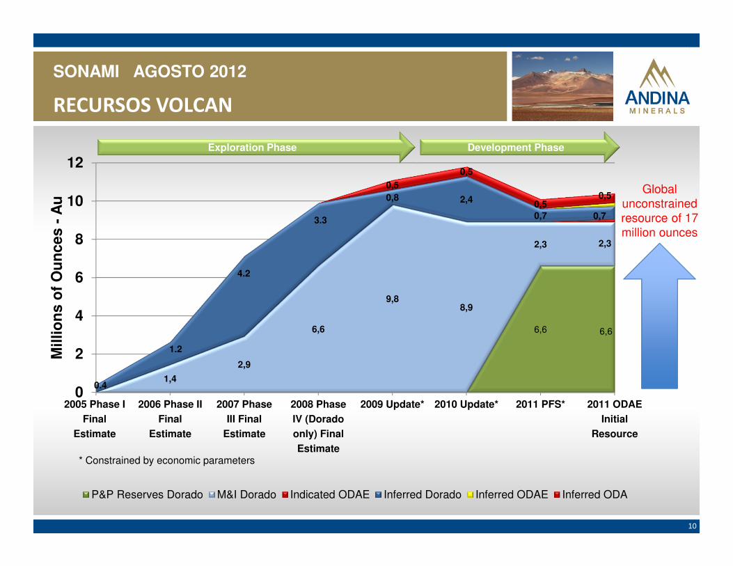
10
RECURSOS VOLCAN
6,6 6,6
1,4
2,9
6,6
9,88,9
2,3 2,3
0,8 2,4
0,7 0,7
0,5
0,5
0,50,5
0
2
4
6
8
10
12
2005 Phase I
Final
Estimate
2006 Phase II
Final
Estimate
2007 Phase
III Final
Estimate
2008 Phase
IV (Dorado
only) Final
Estimate
2009 Update* 2010 Update* 2011 PFS* 2011 ODAE
Initial
Resource
Mill
ion
s o
f O
un
ces
-A
u
P&P Reserves Dorado M&I Dorado Indicated ODAE Inferred Dorado Inferred ODAE Inferred ODA
Exploration Phase Development Phase
* Constrained by economic parameters
0.4
4.2
3.3
1.2
Global unconstrained resource of 17 million ounces
SONAMI AGOSTO 2012

11
� 100% propiedad de Andina Minerals.
� 120 km al Este de Copiapó.
� Comunas de Tierra Amarilla y Copiapó; Región de Atacama.
� Porfido tipo Maricunga, de Tres cuerpos mineralizados.
� Explotación a Rajo Abierto.
� 60.000 t/d de Mineral / 0,64 g/t de ley media
� 15 años de vida útil mas tres de Cierre.
� 450 personas durante Operación
� 1480 personas durante Construcción.
� US$ 800.000.000 estimada
� 2013 Inicio estimado de actividades de construcción
Andina Minerals
Proyecto Volcan

12
MINAMINA
CHANCADO(1ro – 2ro – 3ro)
CHANCADO(1ro – 2ro – 3ro)
Alta Ley
BajaLey
LIXIVIACIONPILAS
LIXIVIACIONPILAS
MOLINOMOLINO
MATERIALFINO
LIXIVIACIONAGITACIONLIXIVIACIONAGITACION
PLANTAPROCESOS
PLANTAPROCESOS
METALDORE
Separador de
Finos
Separador de
Finos
SONAMI AGOSTO 2012
PROYECTO VOLCAN - CONCEPTO DE DISEÑO

13
MINAMINA
CHANCADO(1ro – 2ro – 3ro)
CHANCADO(1ro – 2ro – 3ro)
AL BL
LIXIVIACIONPILAS
LIXIVIACIONPILAS
MOLIENDAMOLIENDA
LIXIVIACIONAGITACIONLIXIVIACIONAGITACION
PLANTAPROCESOS
PLANTAPROCESOS
METALDORE
SONAMI AGOSTO 2012
SEPARADOR FINOS
SEPARADOR FINOS

14
Ubicación del proyecto con respecto a lagunas
Rajos/Botaderos
Laguna Negro Francisco
Salar de Maricunga
Planta

15
Andina Minerals
Planta de Procesos
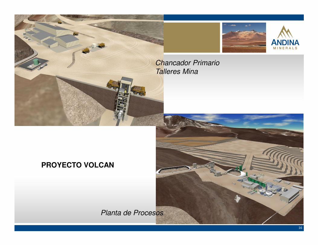
16
Planta de Procesos
Chancador Primario
Talleres Mina
PROYECTO VOLCAN

17
SBX – ADM – MICON SRK – NCL – MAPTEK
MAGRI Consultor.
ADM – HATCH – KCA Q’Pit - AUSENCO –DESSAU - KHD -
SWS- BGC- FN - B&M CPH - AAL
ADM – KCA – Q’Pit -MICON – GOLDER –
SWS – DESSAU –ALQUIMIA - PIDDO
Geología Estudio Conceptual Prefactibilidad y Factibilidad
MATERIAS AMBIENTALES
ADM - FN – KCA - BGC – GHD – AAL – SWS – GOLDER J. GONNET – CPH - CEC
ADM - FN – KCA - BGC – GHD – AAL – SWS – GOLDER J. GONNET – CPH - CEC
Andina Minerals – Participantes principales

18
Z3
Z0
Z1
Z2
Z4
Cuenca Salar de Maricunga
Cuenca Lagunadel
Negro Francisco
Proyecto SubcuencaDerechos
subterráneos (l/s)
Nº PozosAprobación
CONAMA (l/s)
Derechos superficiales
(l/s)Subcuenca
Refugio Z1 258 3 95
Marte-Lobo Z2 200 2 440 Z1, Z2 y Z3
Volcán Z2 247 2
La Coipa Z3 441 9
Can Can Z3 62 1
TOTAL 1.208 17 95 440
Parque Nacional Laguna Santa Rosa Área: 47.035 Has
Sitio RamsarComplejo Lacustre Laguna del Negro Francisco y Laguna Santa Rosa Área: 62.460 Has
Sitio RamsarComplejo Lacustre Laguna del Negro Francisco y Laguna Santa Rosa Área: 62.460 Has
Parque Nacional Laguna del Negro Francisco Área: 15.425 Has
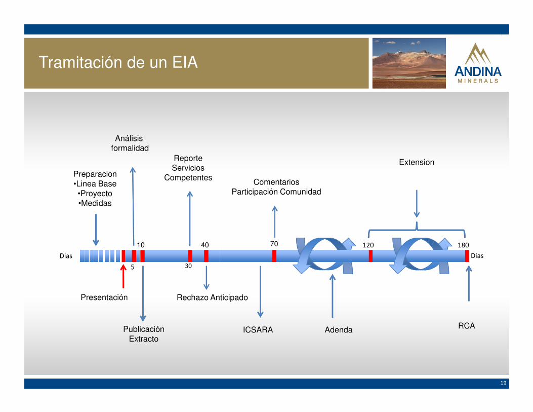
19
Preparacion•Linea Base•Proyecto•Medidas
Presentación
Análisisformalidad
ReporteServicios
Competentes
PublicaciónExtracto
ComentariosParticipación Comunidad
Rechazo Anticipado
ICSARA RCA
Extension
10
30
40 70
5
180120
Adenda
DiasDias
Tramitación de un EIA

20
MUCHAS GRACIAS
SONAMI AGOSTO 2012
ANDINA MINERALS


![Unidad6 Mezcla Agitacion[1]](https://static.documentos.tech/doc/80x56/56d6bcf21a28ab30168c187e/unidad6-mezcla-agitacion1.jpg)

